
Charlotte's Arc and Wedge
The 2040 Comprehensive Plan, being developed by the Charlotte City Planning Department, has designated the city into two distinct categories: The Arc and The Wedge
Slide 11 of the Charlotte Future 2040 Comprehensive Plan Presentation
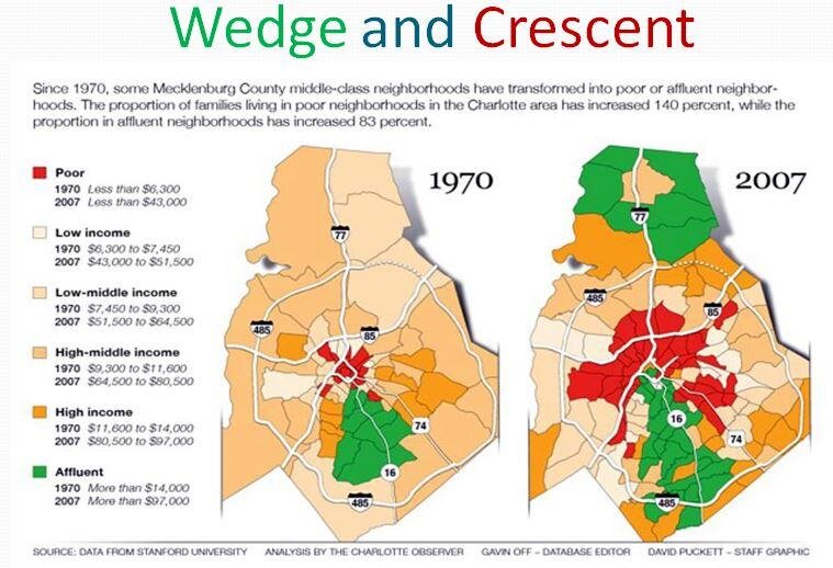
Wedge and Crescent
The Arc & The Wedge evolved from the Wedge and the Crescent, a term originally used to describe Charlotte’s voting patterns. Since then, Wedge and Crescent has been used to describe everything from income, schooling, race, food deserts, and even the COVID infection rate.
Wedge and Crescent identifies two geographic Charlotte regions that have dissimilar demographics.


The Arc and The Wedge
The Charlotte Future 2040 Comprehensive Plan did a deep dive into the historical and current demographics that are found in the wedge and crescent. They took this data and expanded it to the entire city, defining The Arc and The Wedge as outlined in the Built City Equity Atlas . This report evaluates equity distribution within Charlotte and how the land use planning process and development patterns can address identified inequities.


The Missing Sections
While the Built City Equity Atlas does encompass the entire city of Charlotte, The Arc and The Wedge does not. It is not clear why the graphic excludes parts of North Charlotte and Steel Creek, nor are these areas given an identity or a label. Also, Pineville, which occupies both The Arc and The Wedge, is included in the map, while the other five towns are not.

Update on May 20, 2021
Page 5 of the 2040 Comp Plan - Recommended Draft Plan Volume One Published May 20, 2021
Make Your Own Map
The Charlotte Mecklenburg Quality of Life Explorer applies city and county data into a mapping program and even allows you to see data progression over the years. You can look at a multitude of demographic information: Rental Housing, Age of Death, Tree Canopy, and even Library Card Holders
Charlotte/Mecklenburg Quality of Life Explorer (mcmap.org)
