Charlotte’s New Micro Transit Plan
Charlotte’s Micro Transit
Filling the Gaps Between Neighborhoods and Transit Lines
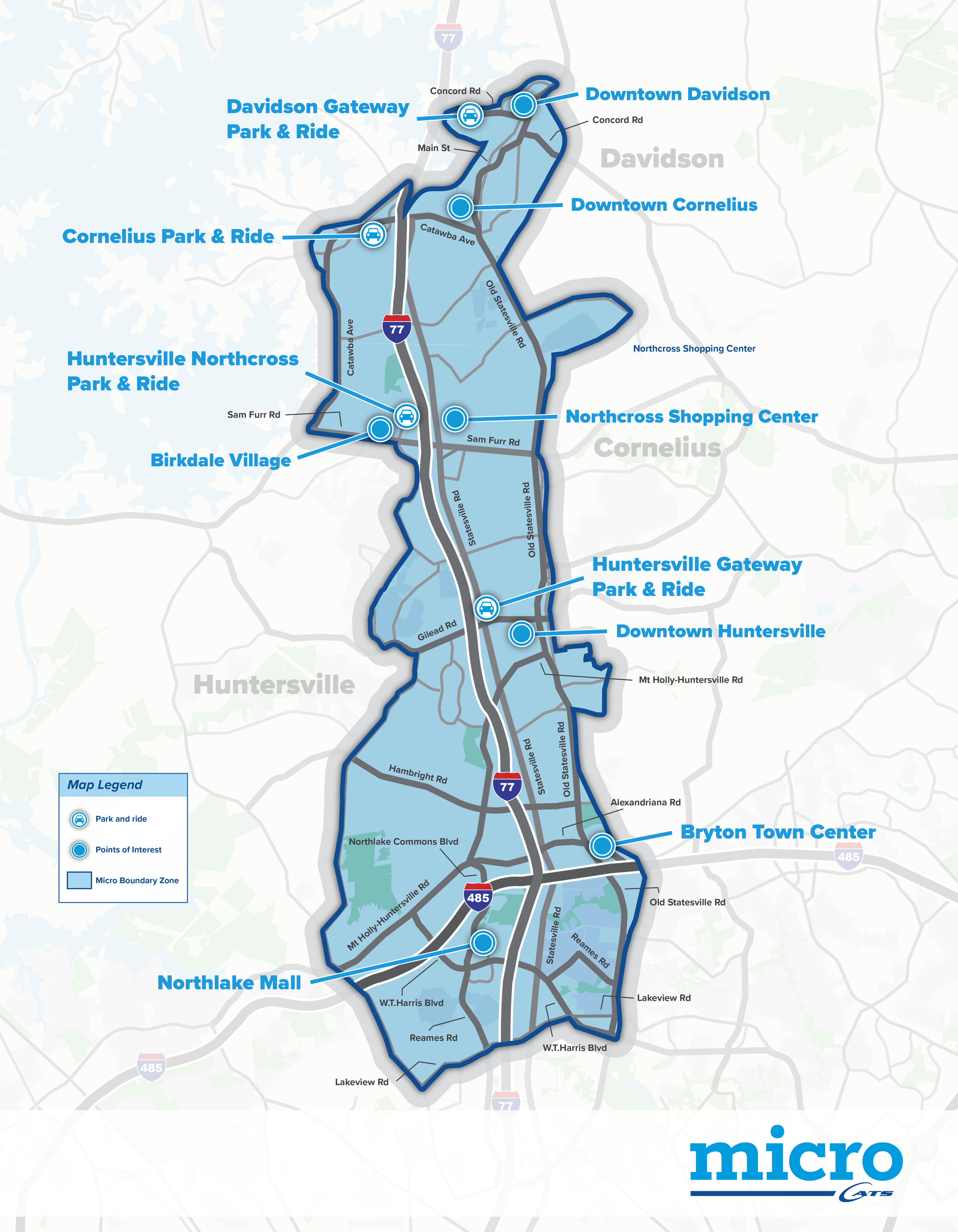
Current Micro Transit Zone
Micro Transit is a flexible, on-demand ride service operated by Charlotte Area Transit System (CATS) that connects residents within specific neighborhoods using small vans. Riders request a trip via the CATS-Pass app or by phone, entering both their pickup and drop-off locations—both of which must fall within the same zone. Once booked, riders walk to a nearby virtual stop, typically a few minutes away, and share the ride with others heading in the same direction.
As of now, Micro Transit is only operating in North Mecklenburg. But the city is preparing to take this service further. What began as a small initiative is evolving into a broader citywide strategy focused on closing transportation gaps, improving last-mile mobility, and offering more responsive connections to bus and rail lines—particularly in areas where fixed-route service has failed.
When fully launched, the fare will be $2.20, equal to a standard CATS bus ride and inclusive of free transfers. The service isn’t meant to replace traditional transit, but to complement it—filling in the gaps for riders without easy access to high-frequency corridors, park-and-ride lots, or safe walking options.
New Micro Transit Zones on the Horizon
In West and Southwest Charlotte, five zones are being planned: Steele Creek, West Boulevard, Shopton Road–River District, Pawtucket–Coulwood, and Westinghouse. These areas include key job hubs and emerging neighborhoods that currently have limited transit access.
In North Charlotte and North Mecklenburg, Micro Transit will expand into Prosperity Church Road, Nevin–Derita, and the towns of Davidson, Cornelius, and Huntersville. These zones aim to address existing last-mile mobility issues and support future commuter rail infrastructure.
Next up are East and Southeast Charlotte, where growth has outpaced traditional service. New zones will include Matthews, Harrisburg–Albemarle, Mint Hill, and Marshbrooke.
In South Charlotte and Ballantyne, planned zones such as Pineville, Ballantyne, Park Crossing, Quail Hollow, and Starmount are expected to relieve congestion and offer a practical transit option for daily commuters.
Each zone functions independently but is designed to integrate into the broader CATS system. Riders can use Micro Transit to reach major transfer hubs, including bus stops or light rail stations, and continue their journeys across the region.
Early Results and Community Feedback
More than 7,000 riders have already used Micro Transit, with average wait times clocking in under eight minutes. In North Mecklenburg – where the service replaced underused bus routes—the transition has shown early signs of success. While the cost per rider is higher than that of traditional bus service, Micro Transit often delivers better results in suburban areas where fixed routes generate low ridership and poor reliability.
For instance, a resident of University City could take Micro Transit to the UNC Charlotte–Main light rail station for $2.20, then transfer to the Blue Line for an additional $2.20 to reach Uptown. The $4.40 total covers nearly 20 miles of travel without needing to drive or park.
Looking Ahead
Charlotte’s Micro Transit program is a part of the city’s Better Bus Plan—a comprehensive effort to modernize public transportation in a way that keeps up with how people move today. As more zones come online, Micro Transit will shift from a pilot program to potentially a long-term mobility solution: one that promises more reliability and a more equitable transit experience for all of Charlotte.
Article written by Daryna Maznytska